
Friday, June 18, 2010
Where is the Oil Spill?
It's the largest environmental disaster in U.S. - and possibly world - history.
But do you know exactly where it is? Could you point to a map and show where the oil rig sank?
Do you know what the topography of the surrounding area is? Hint: If you think it's flat seafloor - as implied by BPs drawings - you'd be wrong (the spill site is actually located within a giant canyon system, rather than on flat ground).
This essay will provide some basic orientation as to ground zero for the oil spill.
Where Is the Spill Site?
Here is the spill site - designated with the fire icon - as shown on Google maps:
 (click on this or any image in this essay to see a larger and clearer version of the image).
This NOAA image gives a basic overview of the oil spill site in relation to the surrounding area:
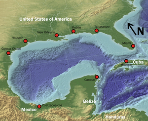
Here is an image showing the Mississippi Canyon compared to other areas in the Gulf of Mexico:
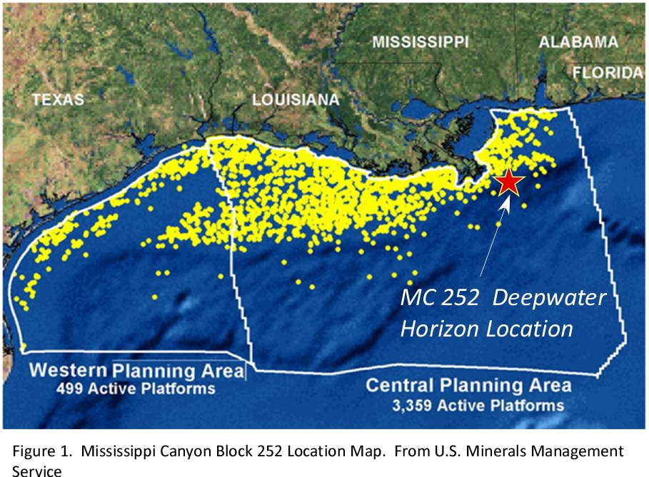
Here is Block 252 shown in comparison with nearby sites:
But in order to really get a feel for what's happening underwater, we should look at detailed topographic maps. Indeed, knowing the topography and the geology at the spill site is crucial in understanding the risks involved and being able to determine the best approach for stopping the leak.
Topography of the Spill Site
Here's a map of the Gulf of Mexico:
Here's another map courtesy of Wired (the spill site is between the two sets of red hash marks):


Here is a satellite image of the area provided by the Minerals Management Service and NOAA's Multipurpose Marine Cadastre:

Here is a close-up (I placed a hand icon at the approximate location of the oil spill based on latitude and longitude):
 Here is an image - courtesy of NOAA's GeoPlatform service - showing the topography surrounding the leaking wellhead:
Here is a close up of the same image:

Here is the same image with the spill location indicator removed, so that you can see the slope of the area at the spill site:

(Note: the GeoPlatform service is also very useful for forecasting the near-term trajectory of the oil spill).
Here is a map giving a different view of the steep canyon in which the oil spill site is located:

(1) The spill site is located in a steep canyon, as discussed above;
(2) There are hundreds of feet of loose mud and muck on top of the sea floor in this area; and
(3) Many deepwater, oil-rich areas within the Gulf are tectonically active, and the Mississippi Canyon was - in the relatively recent geologic past - highly unstable.
7 comments:
→ Thank you for contributing to the conversation by commenting. We try to read all of the comments (but don't always have the time).
→ If you write a long comment, please use paragraph breaks. Otherwise, no one will read it. Many people still won't read it, so shorter is usually better (but it's your choice).
→ The following types of comments will be deleted if we happen to see them:
-- Comments that criticize any class of people as a whole, especially when based on an attribute they don't have control over
-- Comments that explicitly call for violence
→ Because we do not read all of the comments, I am not responsible for any unlawful or distasteful comments.


I find it interesting that you seem to more about all of this than a certain person who is yachting this weekend.
ReplyDeleteIt's about time that someone pointed out the seismic activity out. It would have helped to be able to view the munitions dumps within this area. We are in very unknown water right now, and I don't believe that anyone truly has full understanding of worst case scenario.
ReplyDeleteRADIOACTIVE GULF OIL ???
ReplyDeletehttp://poleshift.ning.com/profiles/blog/show?id=3863141%3ABlogPost%3A85207&commentId=3863141%3AComment%3A85957&xg_source=activity
"Initial radiation tests on a sample of oil washing ashore near Shalimar Florida conducted on Friday seem to confirm that the oil coming from the Deep Horizon blow out is carrying some radiation.
"The ad hoc testing was conducted by the webmaster and owner of the popular conspiracy site "Godlike Productions.com" Trinity" aka Jason Lucas.
http://www.godlikeproductions.com/forum1/message1104630/pg1
(See the geiger counter video in the first entry.)
"The radiation meter used to test the sample is a surplus Civil Defense meter CDV 700 quote "CD V-700 is a low-range meter more suited for peacetime use than the above three high-range CDV-715's, 717's and 720's."
Article continues at http://rense.com/general91/glf.htm
Related article at http://rense.com/general91/d2se.htm
"This is going to blow the roof off of the scope of this disaster. This is why people are getting sick. This is why they are using Corexit in such quantities, this is why there aren't many ships out there. The radioactivity is beyond safe levels."
It's the largest environmental disaster in U.S. - and possibly world history.
ReplyDeleteNO it is nowhere near the worst !
The 1st gulf war was by far the worst with 100 times as much oil spilled into the arabian gulf and much more burned.
It's about time that someone pointed out the nature of the Mississippi Canyon - we can now better appreciate the risks that BP and other companies are taking than before this discussion.
ReplyDeleteNow if we could fathom the risks involved with the Oval Office.
www.usaliberalism.com
Do you also have any idea of where the huge oil spill of the 1970's occurred in the Gulf of Mexico? I understand it took them 10 months to repair that one, and that well was only 150 deep.
ReplyDeleteHAS ANYONE looked at the geomagnetic survey carried out in the gulf in 2004.
ReplyDeletethere are a lot of Tar Volcanoes in the area of the rig.And by the look of these maps they BP deliberately drilled into the side of one of these babies. that is why there is no huge amounts of ail.
How did they drill the relief wells so quick ???
The Corexit which BP pumped in to kill every thing and every one even kill the oil eating microbes.Burn"t off and caused crop damage and toxic poisioning in USA Europe etc
Check out any or all of these words no links given find things out for yourself at least you know you can TRUST that person YOU>
Free energy
corexit
ponies and balloons
geomagnetic survey gulf 2004
tar volcanoes
crop damage